Introduction
This page describes the translation of scientific skill to public value, specifically in water resource management and related impacts on human communities. We are building a Dynamic Information Framework (DIF) that is implemented on a region-by-region basis to provide both data and machinery in a transparent manner that contributes to the process of resource management and planning.
Objective and Approach
Governments increasingly need to anticipate and acquire the knowledge and capacity to respond to environmental change. Modern earth system science (ESS), with its dynamic geospatial expression of the globe, is rapidly evolving with the sophistication capable of addressing the complexities of regional resources. In practice, the abilities required to identify and implement such tools and their data products are largely absent in much of the non-academic world. Our aim is to explore the development of a strategy for decision support systems capable of providing governments with gateways to “actionable information,” through development of a multi-sector Dynamic Information Framework (DIF) that integrates land surface models with local and global data sources and stakeholder-driven goals. Through a series of projects, in collaboration with the World Bank Group (WBG), prototype applications in hydrologically and geopolitically diverse regions, we identified three key elements to develop a viable decision support tool that leverages modern ESS. First, assembling from the beginning a local, cross sector expert team led by a strong proponent is critical; second, global and local data need to be melded, finally complex modeled outcomes and scenarios need to be presented in compelling and easy to understand formats. Increasingly, web-based visualization tools are being used by a range of stakeholders to access information in near real-time. Deploying the DIF in the cloud is a means of compensating for lack of local computing and data infrastructure. A boundary organization (e.g., the WBG) is important to facilitate communication between DIF developers and local stakeholders.
Solution
Results
Warnings
- No concerns at this time.
Overview
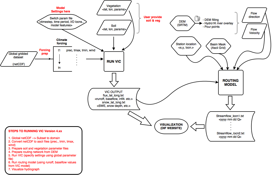
This figure shows a simplified version of the DIF vision with one modeling component, the VIC hydrological model. The overall program for DIF can be summarized on a per-geographical-region basis:
- Begin with A hydrological model that incorporates observed data; train it to produce accurate results.
- Run the model into the future based on climate-change based extrapolation.
- Provide the source data through an open web interface
- Provide the results / output data through an open web interface
- Provide the software via an open repository like GitHub
- Provide documentation
- Repeat